| Jean-Arthur Olive |
|
Overview
The Earth’s lithosphere is fragmented into tectonic plates that move rigidly and only deform within narrow boundary zones. My research focuses on strain localization in the brittle upper part of the lithosphere, i.e., the formation and evolution of major fault systems. On human time scales, this process manifests as earthquakes while over geological time it shapes mountains and basins. Faulting also interacts with a range of geological phenomena such as erosion, sedimentation, magmatism, and hydrothermal circulation.
To better understand the physics that underlie brittle deformation and its geological controls, my group and I develop models that relate the morphology, structure and ongoing deformation of plate margins to the rheological properties of the lithosphere, and the forces that act on it.
To better understand the physics that underlie brittle deformation and its geological controls, my group and I develop models that relate the morphology, structure and ongoing deformation of plate margins to the rheological properties of the lithosphere, and the forces that act on it.
Brittle deformation across scales
Connecting short- and long-term deformation at tectonic plate boundaries
Earthquakes are the most spectacular manifestation of brittle deformation on our time scales. They correspond to the sudden release of elastic energy accumulated around parts of a fault that were frictionally stuck for a long time. Repeated events of seismic (and aseismic) slip lead to finite offset on faults, which deforms the adjacent crustal blocks in a largely inelastic (non-recoverable) fashion. What is the connection between seemingly elastic seismic cycles and long-term "permanent" deformation, which shapes landscapes and geological structures? We are currently investigating these questions at subduction zones and extensional plate boundaries.
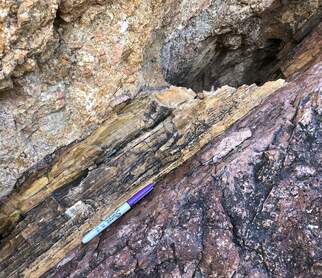
Mechanisms of brittle deformation
Non-recoverable deformation of the upper crust involves a range of deformation mechanisms, from pressure solution flow to pervasive micro-cracking and large-scale faulting. Fault initiation is typically preceded and accompanied by distributed brittle strain, which at the scale of the crust manifests as inelastic flexure and folding. By combining field observations, micro-mechanical and tectonic modeling, we seek to develop novel parameterizations of brittle rheologies that connect the large-scale behavior of the crust to its small-scale underlying mechanisms.
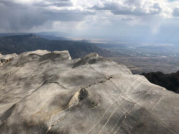
Field work in the Sandia Mountains, New Mexico, a natural laboratory where inelastic flexure of the Rio Grande rift shoulder manifests as pervasive cracking.
|
|
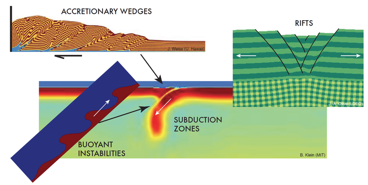
Seafloor spreading
What's shaping the Earth's seafloor?
About 2/3 of Earth’s surface originated somewhere along the global mid-ocean ridge system, where faulting, magmatism and hydrothermal processes interact to shape new oceanic tectonic plates. We broadly seek to understand how this complex interplay can produce the diversity of seafloor textures observed across the world’s ocean basins, from regularly-spaced abyssal hills to irregular bathymetric highs capped by large-offset detachment faults.
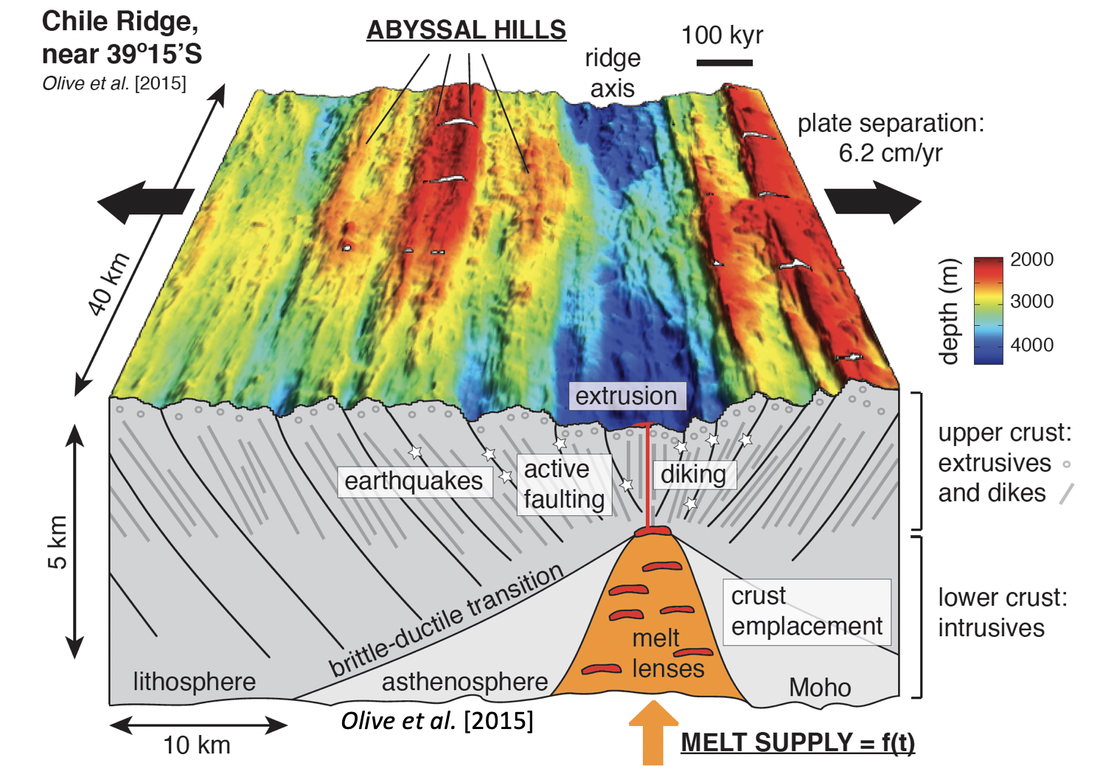
Key processes that shape new seafloor at mid-ocean ridges.
|
|
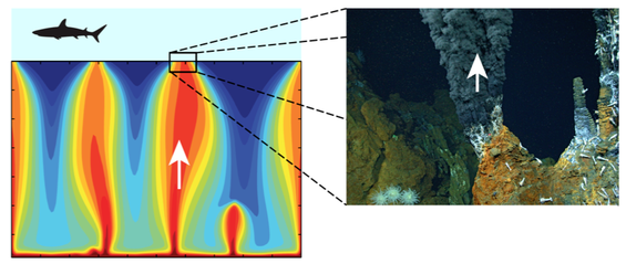
Hydrothermal systems: interface between the lithosphere and hydrosphere
Where there are faults, there are (generally) fluids. At mid-ocean ridges, fluid circulation in the crust is a primary means of heat extraction and chemical exchange between the solid and fluid Earth. We are particularly interested in the parameters that control the depth-extent of hydrothermal circulation, and its consequences for the strength and thermal state of young oceanic lithosphere.
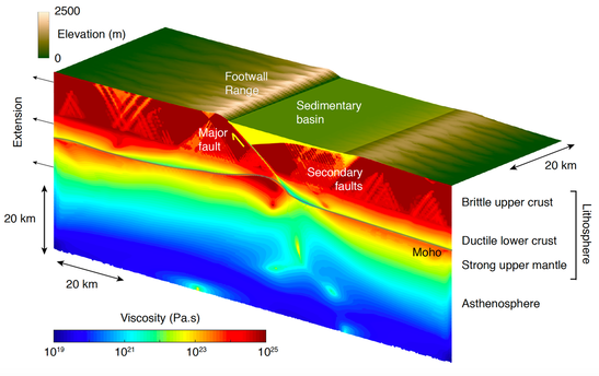
Tectonics vs. surface processes
Surface processes constantly rework the relief created by active faults. This in turn alters stresses in the lithosphere, which affects the long-term evolution of faults. For example, in continental rifts, alleviating the topographic load of a footwall range and hanging wall basin by erosion and sedimentation can enhance the life span of a normal fault, and influence subsequent strain localization.
By developing models that couple lithosphere deformation and landscape evolution, we seek to quantify these types of feedbacks in a variety of tectonic settings, and identify their signature in the geological record.
By developing models that couple lithosphere deformation and landscape evolution, we seek to quantify these types of feedbacks in a variety of tectonic settings, and identify their signature in the geological record.
Coupled model of rifting and landscape evolution.
Numerical geodynamic modeling
Numerical modeling of long-term lithosphere and mantle dynamics poses numerous challenges. A geodynamic modeling code typically handles very large, very localized deformation, non-linear rheologies with sharp contrasts, an evolving free surface... and must be able to do so in two or three-dimensions in a relatively fast manner. Along with colleagues at WHOI, MIT, and the Universities of Hawaii and Idaho, I have developed a simple Matlab code for modeling 2-D long-term deformation of the lithosphere. This code, aptly named SiStER, for Simple Stokes solver with Exotic Rheologies, is based on the finite-difference / marker-in-cell technique described by Gerya (2010), and largely builds on Matlab's capabilities for rapid vector and sparse matrix operations. SiStER is now widely distributed on Github, and can be used as both a research and teaching tool.
Another important aspect of computational geodynamics consists of making sure that the basic assumptions of our models are valid on a fundamental level. I have for example worked on the importance of elasticity in long-term lithosphere evolution models, and am now investigating novel ways to model distributed brittle deformation of the upper crust.
